


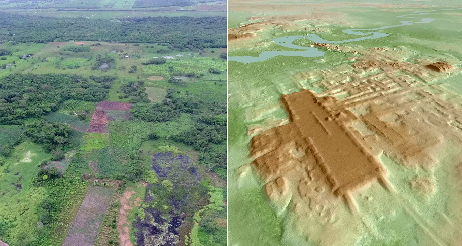
The plateau looked like a hill.
From the ground, walking across the Aguada Fénix section of Tabasco, Mexico near the northwestern border of Guatemala, there was nothing visible to suggest that the slightly elevated ground underfoot was anything other than natural topography. The local population lived on and around it. Agricultural fields covered its surface. No stones protruded from the soil to suggest buried architecture. No local tradition had preserved the memory of what lay beneath the cultivated landscape.
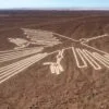
From the air, with a LIDAR laser system detecting ground surface elevation through the forest canopy and agricultural cover, the platform resolved into one of the most significant archaeological discoveries in Mesoamerican research.
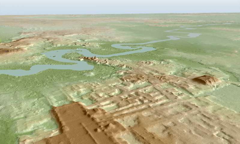
Takeshi Inomata and Daniela Triadan, professors at the University of Arizona’s School of Anthropology, identified the site through low-resolution LIDAR data provided by the Mexican government and confirmed it with high-resolution LIDAR surveys conducted specifically to characterize the feature. What the data revealed was a rectangular platform approximately 1,400 meters in length, between 9 and 15 meters in height, with nine wide causeways extending outward from its main axis, surrounded by smaller platforms, dams, and reservoirs whose configuration indicated a planned ceremonial complex rather than a natural landform.
The team excavated the site and submitted 69 charcoal samples to radiocarbon dating. The results, published in the journal Nature in June 2020, established construction between approximately 1000 and 800 BCE.
The Aguada Fénix is the largest known Mayan monument ever documented. It is also the oldest, predating the previously confirmed earliest Maya ceremonial center, the Ceibal site in Guatemala dated to approximately 950 BCE, and far exceeding in volume the pyramids and palace complexes of the Classic Maya period that followed it by a thousand years.
It was not built by pharaohs. It was not built by kings. The evidence the excavation produced showed no stone monuments to elite rulers, no carved stelae commemorating individual leaders, no architectural evidence of the social hierarchy that the conventional model of monumental construction assumes as its prerequisite.
Whatever motivated the construction of the largest building in all of Maya history, it was not a king ordering his subjects to build him a monument.
LIDAR and What Was Hidden
The technology that revealed Aguada Fénix is worth understanding because it is transforming the archaeology of forested regions worldwide and establishing that the conventional picture of ancient civilization’s geographic extent and population density has been significantly underestimated.
LIDAR, Light Detection and Ranging, uses laser pulses emitted from aircraft to measure the precise distance to the ground surface below. In forested areas, the laser penetrates the canopy through gaps between leaves and branches, and the returns from the ground surface reveal the underlying topography at resolutions of several centimeters, sufficient to detect architectural features whose elevation above the surrounding terrain is measurable even when cultural material has been buried under soil and vegetation for thousands of years.
The technology was applied to Maya archaeology at transformative scale by the PACUNAM LIDAR Initiative, whose 2018 survey of approximately 2,100 square kilometers of northern Guatemala revealed approximately 60,000 previously unknown architectural features, including fortifications, causeways, agricultural terraces, and settlement patterns whose total implication was that the Classic Maya lowlands had supported a population of 7 to 11 million people, three to four times the conventional estimate and comparable to the most densely settled regions of pre-industrial Europe.
The PACUNAM results required a fundamental revision of how Maya civilization is understood: not a series of independent ceremonial centers surrounded by thin forest settlements, but a densely interconnected urban landscape whose character had been invisible to conventional survey methodology because the forest concealed it.
Aguada Fénix’s discovery extends this revision back to the Preclassic period by establishing that the construction of massive communal ceremonial architecture in the Maya lowlands predates the Classic period’s known complexity by a thousand years.
What else is hidden under the forest canopy and agricultural fields of Mesoamerica that conventional survey methodology has missed is a question that the LIDAR data, as it extends its coverage across the region, is systematically beginning to answer.
The Social Structure Problem
The finding that challenges conventional Mesoamerican archaeology most directly is not Aguada Fénix’s size or its age but the social conditions under which it was built.
The conventional model of monumental construction in pre-Columbian Mesoamerica, developed from the architectural and textual record of the Classic Maya and Aztec periods, treats large-scale architecture as a product of elite political power: a ruling class with the authority to organize and compel the labor of subject populations, the institutional infrastructure to manage multi-year construction projects, and the ideological motivation to commemorate their authority in permanent stone.
Aguada Fénix’s architectural record contradicts this model for the period of its construction. The site shows no stone stelae carved with elite portraits or dynastic inscriptions, which are the standard archaeological signature of the individualized rulership that characterized Classic Maya monumental construction. The spatial organization of the platform, whose design Inomata’s team characterizes as a communal open space rather than a restricted ceremonial precinct serving an elite, is inconsistent with the exclusive ceremonial architecture of later periods.
The construction’s labor demands were enormous regardless of its social organization. A platform 1,400 meters long and up to 15 meters high, built from clay and earth fill rather than cut stone, represents a total volume of construction material whose movement and placement required coordinated labor at scales comparable to the later pyramid complexes. Whether this labor was organized through community obligation, ceremonial motivation, shared cosmological commitment, or some institutional framework whose character the archaeological record does not fully preserve, is the question that the absence of elite monuments leaves open.
Inomata’s team proposes that the Aguada Fénix construction reflects a model of communal labor organized around shared ritual purpose rather than elite command: thousands of semi-nomadic people who lived in the region and participated collectively in a construction project whose meaning was communal rather than dynastic.
Whether this model is correct has implications that extend well beyond the Maya lowlands: it suggests that the organizational capacity for massive coordinated construction projects existed in human populations before the development of coercive political hierarchy, and that the conventional model of civilization’s development, in which monumental architecture requires and demonstrates the prior development of centralized authority, may need revision.
The Olmec Connection
The architectural parallel that Inomata’s team documented between Aguada Fénix and the Olmec site of La Venta is the finding whose implications for the broader pre-Columbian contact and cultural transmission question are most significant.
La Venta, the primary Olmec ceremonial center in Tabasco, is located in the same general region as Aguada Fénix and dates to approximately 800-400 BCE, overlapping with the later phases of Aguada Fénix’s construction period. The two sites share architectural characteristics including the orientation of their main axes, the arrangement of causeways relative to the central platform, and proportional relationships in their construction dimensions that suggest either direct cultural exchange, shared architectural traditions derived from a common earlier source, or parallel development in response to the same cosmological framework.
The Olmec piece in this library documents the anomalies of Olmec civilization, including the African-featured colossal heads, the wheeled animal toys, the undeciphered Cascajal Block script, and the Caucasian-featured La Venta stelae whose diverse racial representation remains unexplained. The Aguada Fénix connection to La Venta places the Maya emergence in direct relationship with this most anomalous of Mesoamerican civilizations.
Whether the shared architectural vocabulary between Aguada Fénix and La Venta reflects Maya reception of Olmec influence, Olmec reception of an emerging Maya tradition, or both traditions drawing on a common earlier ceremonial architecture whose origin is not recorded in the current archaeological record, is the question that the geographic proximity and temporal overlap of the two sites motivates without the available evidence resolving.
The Maya are conventionally understood as the inheritors of the Olmec tradition, the mother culture whose innovations in ceremonial architecture, astronomical observation, and symbolic representation were transmitted to the Maya and subsequently elaborated over the following two millennia.
Whether the mother culture model accurately describes the relationship, or whether both the Olmec and the early Maya were parallel elaborations of an even older tradition whose character the Preclassic archaeological record is beginning to reveal, is the question that Aguada Fénix’s 1000 BCE construction date and its architectural parallels with La Venta places in research focus.
What Conventional Survey Missed
The Aguada Fénix discovery raises a methodological question about the limits of conventional archaeological survey that has implications for the library’s broader framework: if the largest monument in all of Maya history was invisible to conventional survey methodology and required LIDAR to identify, what else has conventional methodology missed across the ancient world?
The conditions that made Aguada Fénix invisible to conventional survey are documented. Its low profile, approximately 9 to 15 meters high across a 1,400-meter length, produced a slope too gradual to register as obviously artificial from the ground. Its clay and earth construction left no stone markers on the surface. Its agricultural use by current populations meant that the land was continuously disturbed without anyone recognizing the significance of the terrain. And its forest-free, agricultural setting meant that it was not in the category of sites where LIDAR surveys were initially deployed, which focused on areas with dense forest canopy.
These are not unusual conditions for ancient earthwork construction. Earthwork monuments, built from clay, soil, and gravel rather than from cut stone, are the dominant form of monumental construction in many ancient traditions: the Earthwork traditions of the American Midwest and Southeast, the henges and long barrows of Neolithic Britain, the burial mounds of Bronze Age Europe and Asia, and numerous Mesoamerican platform complexes share the characteristic of being low-profile soil constructions whose recognition requires either LIDAR survey, precise topographic analysis, or the kind of local knowledge that tends not to make it into the academic literature.
Whether similarly large and similarly hidden ancient monuments exist across Mesoamerica, across the Amazon basin whose LIDAR surveys have already revealed extensive pre-Columbian earthwork systems, or across other regions where the conventional survey methodology was applied to a landscape whose actual archaeological content it was not capable of detecting, is the question that Aguada Fénix’s discovery makes specifically urgent rather than speculatively interesting.
The largest Maya monument was under everyone’s feet for three thousand years.
The LIDAR looked down and saw it.