The friar who described them was dismissed as a fantasist for five centuries.
Gaspar de Carvajal, a Dominican friar who accompanied Francisco de Orellana’s 1541 expedition down the Amazon River, kept a detailed account of what he saw. His chronicle describes continuous settlements along both banks of the river for hundreds of kilometers. Cities larger than Seville, the largest city in Spain at the time. Roads connecting settlements. Agricultural terraces cut into the riverbanks. Ceramic production on an industrial scale. River traffic so dense that the expedition’s small boats navigated between hundreds of vessels carrying goods and people between cities.
Carvajal was a trained observer who had no motivation to fabricate a record that would be submitted to the Spanish crown. His chronicle was in its geographic references, consistent in its descriptions, and supported by corroborating accounts from other members of the expedition.
It was dismissed as exaggeration or fantasy for five hundred years.
The academic consensus that formed around the Amazon in the nineteenth and twentieth centuries was broad and confident: the basin could not have supported complex civilization. The soil was wrong. The laterite soils of the tropical rainforest, heavily leached by rainfall and poor in nutrients, could not produce the agricultural surplus that civilization requires. The environment was too hostile. The disease burden too high. The population density that Carvajal described was simply impossible given the ecological constraints.
The consensus was wrong. The evidence that overturned it was in the ground the entire time.
The Soil That Should Not Exist
The first crack in the consensus came from the dirt.
Scattered across the Amazon basin in patches ranging from a few hectares to several thousand hectares is a soil type that has no natural explanation. Dark, almost black, rich in charcoal, bone fragments, and organic matter, with fertility that persists thousands of years after the human activity that created it ceased. The Brazilians call it terra preta, black earth. It is the most fertile soil in the Amazon and it was made.
Deliberately. Systematically. Over centuries of careful management.
The charcoal component, the type of charred organic material called biochar that gives terra preta its characteristic black color, is not the product of natural fires or casual burning. It is the product of a low-temperature smoldering technique that produces stable carbon structures resistant to decomposition. The biochar locks carbon into the soil in a form that holds nutrients and supports microbial communities for thousands of years. The technique requires knowledge of soil chemistry at a level that the primitive nomadic forager population the conventional account placed in the Amazon did not possess.
The terra preta deposits are not random. They cluster along river systems and at elevated sites that provide drainage. Their distribution maps almost exactly onto the sites where LIDAR surveys have subsequently revealed pre-Columbian settlement infrastructure. The engineered soil and the settlements that produced it are co-located because the settlements were there specifically because the soil was there, or the soil was there because the settlements put it there.
Anna Roosevelt, granddaughter of Theodore Roosevelt and one of the most persistent advocates for Amazonian civilizational complexity before the LIDAR era, conducted excavations at Marajó Island at the mouth of the Amazon in the 1980s that produced ceramic traditions of extraordinary sophistication dated to the first millennium CE, evidence of dense population and complex social organization that the conventional account could not accommodate. Her subsequent excavations at Caverna da Pedra Pintada in the 1990s pushed human occupation of the Amazon basin back to at least 11,200 years before the present, far earlier than any mainstream estimate.
Roosevelt’s findings were resisted and marginalized by the archaeological establishment whose consensus she was challenging. The resistance followed the pattern recorded across multiple discovery cases in this library: findings that challenge established frameworks receive institutional skepticism at a level disproportionate to their methodological vulnerabilities.
The LIDAR data vindicated her. When the aerial surveys began producing images of the Amazon basin’s hidden infrastructure, the scale of what they revealed made Roosevelt’s findings look conservative.
What LIDAR Found
Light Detection and Ranging, the laser-based aerial scanning technology that produces three-dimensional models of terrain by measuring the time laser pulses take to return from the ground surface, revolutionized Amazonian archaeology in the same way that X-ray computed tomography revolutionized medicine: it made visible what was always there but had never been seen.
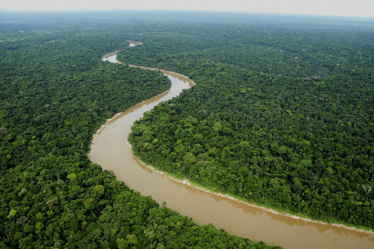
The problem with finding pre-Columbian settlement infrastructure in the Amazon is the canopy. A rainforest canopy dense enough to block satellite photography entirely, a multilayered structure of trees and understory plants that can reach forty meters in height, hides everything below it from conventional aerial or satellite observation. A researcher walking through the Amazon can stand within ten meters of a massive earthwork and not see it because the vegetation has grown over and through the structure for centuries.
LIDAR’s laser pulses penetrate the gaps in the canopy and return from the ground surface rather than from the leaf layer. The resulting ground model strips away the vegetation and shows the terrain as it would appear bare. Pre-Columbian earthworks, roads, causeways, plazas, and platform mounds, all invisible under the canopy, become visible as geometric patterns on the LIDAR ground model.
The surveys have been producing results that are revising every prior estimate of Amazonian civilizational scale upward, sometimes by orders of magnitude.
The 2010 survey of the Caracol site in Belize produced evidence of a city of approximately 70,000 people at its peak, with a road network extending 160 kilometers. The 2018 survey of the northern Guatemalan lowlands revealed approximately 60,000 previously unknown structures including pyramids, causeways, agricultural terraces, and what appear to be defensive earthworks, across an area suggesting a population of several million people at the Maya civilization’s peak, far exceeding previous estimates.
In the Amazon basin proper, surveys have revealed geometric earthworks in the state of Acre in Brazil covering an area of approximately 13,000 square kilometers: ditches, enclosures, and roads arranged in patterns whose regularity indicates centralized planning and construction over extended periods. Satellite surveys of the Bolivian Amazon have revealed a network of raised causeways, canals, fish weirs, and platform settlements in the Llanos de Mojos region whose scale and sophistication indicate a population that managed the landscape at a civilizational level.
The consensus that denied civilization in the Amazon was not simply cautious science applied to limited evidence. It was a conclusion that ignored the evidence of the conquistadors who saw the civilization before it collapsed, dismissed the archaeologists who challenged it, and required the terra preta’s testimony to be attributed to coincidence for decades before the tools to finally refute it were developed.
Montegrande
The hill at Montegrande in the Jaén region of the Peruvian Amazon had been part of the local landscape for so long that people had built houses on top of it. The Peruvian highlands and Amazon interface region is remote and underserved by formal archaeological investigation. The hill was a hill.
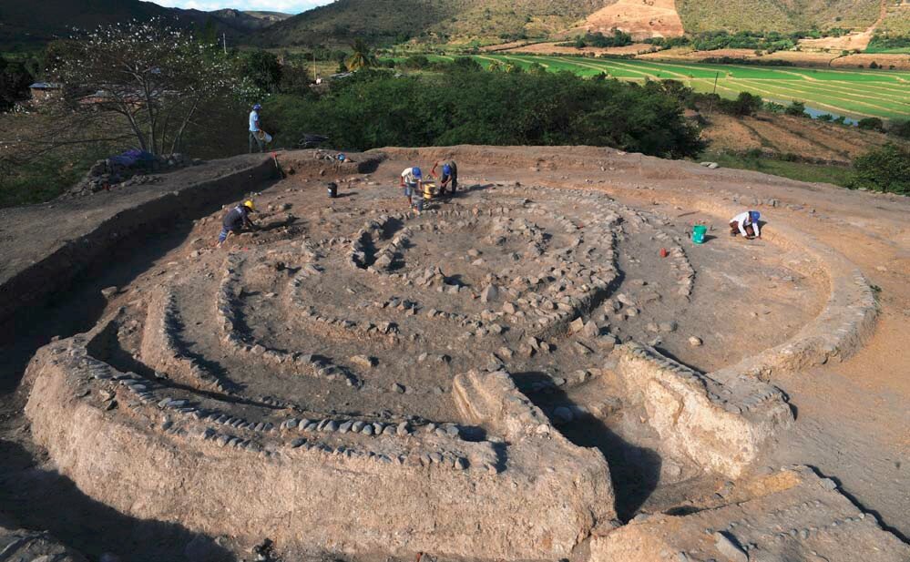
When farmers digging the ground around their houses began finding fragments of ceramics, stone bas-reliefs, and jewelry, local interest eventually translated into a scientific investigation. In 2010 a Peruvian archaeological team arrived. The excavations revealed what the ground survey had not anticipated: a stone pyramid under the accumulated soil of three millennia.
The Montegrande pyramid was not a single construction event. It was built approximately 1000 BCE and rebuilt eight times over the subsequent thousand years of the civilization’s existence, each rebuilding encasing the previous structure in a larger shell, like a Russian doll of progressively larger ceremonial architecture. The rebuilding pattern indicates a civilization with continuous institutional memory, stable enough to maintain a single sacred site across a thousand years of successive construction phases.
Around the pyramid the excavations revealed a city: residential quarters, administrative buildings, a perimeter wall approximately two meters high constructed from stone to protect the settlement from external threats. The wall implies a kind of threat, one that justified the labor investment of constructing permanent stone fortification. The civilization at Montegrande knew enemies.

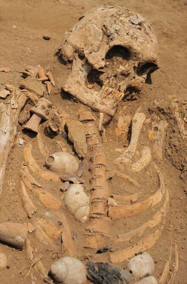
The ceremonial core of the city was at the pyramid’s summit, reached by a path laid through a spiral labyrinth whose form was not architecturally arbitrary. The spiral was this civilization’s central sacred symbol, present in every domain of material culture the excavations recovered. Snail shells, whose natural form is a spiral, were placed on and around burials in quantities suggesting systematic collection and ritual deposition. The dead were covered with them from head to toe. The priests at the pyramid summit consumed plants with hallucinogenic properties that produce visual phenomena described across multiple independent accounts as spiral patterns.
The spiral as cosmic symbol is recorded across cultures on every continent, often in association with shamanic and contact traditions. The monkeyandelf Egypt cluster covers the spiral in the context of Osirian iconography. The consciousness and simulation pieces cover the spiral in the context of non-ordinary awareness states. The Montegrande civilization’s systematic encoding of the spiral across every domain of material culture, from mortuary practice to ceremonial architecture to the visionary states of its priests, places it in a global tradition of spiral symbolism whose origins and meanings the conventional archaeological literature has not unified.
The Mothers and Their Children
Two kilometers from the main pyramid, excavators found a smaller pyramid whose function was revealed by what remained inside it.
Dying children brought here by their mothers. Both the mother and the child sacrificed to the gods.
The archaeological interpretation is that a loving mother, facing the death of a child whose illness or injury was beyond the civilization’s medical capabilities, could choose to accompany the child in death through ritual sacrifice, believing that the act would allow them to reach the afterlife together.
The ritual logic, a living person voluntarily sacrificing themselves to accompany a dying loved one, appears in multiple ancient cultures and reflects a theological proposition: that the conditions of death and the conditions of the afterlife are affected by the actions of the living at the moment of death. A ritual sacrifice at the right location by the right person under the right conditions achieves a different outcome than an unmanaged death.
Whether the theology that drove these sacrifices was correct in its claims about the afterlife is a question the evidence cannot answer. That the civilization held this belief with sufficient conviction to build and maintain a dedicated architectural structure for its practice, and that mothers accepted its terms as a genuine option, is recorded by the remains in the ground.
The civilization that built the spiral city at Montegrande, maintained it for a thousand years, and sacrificed their dying children in the belief that love could follow them beyond death, left no written record. The organic conditions of the Amazon have destroyed everything that would have decomposed. The stone, the ceramic, the bone, and the gold have survived.
The name of the civilization is not known. The language they spoke is not known. The myths they told about the spiral are not known. The theological system that made the mother-child sacrifice an act of love rather than cruelty is known only through the architectural fact of the pyramid and the skeletal testimony of those who died there.
The Network
Montegrande is one node. The LIDAR data is revealing the others.
The Amazon basin’s pre-Columbian population, at the moment of first European contact in the 1540s, was in the process of collapsing from diseases introduced by the contact itself. Smallpox, measles, and influenza moved through populations with no prior exposure faster than the contact frontier itself: diseases introduced at the coast spread into the interior along trade networks, devastating populations that had never seen a European. By the time systematic European exploration reached most of the Amazon basin, the civilization that Carvajal described had been dead for decades or longer.
The jungle reclaimed it with the speed that tropical vegetation can achieve: ten years of abandonment is sufficient to make most structures invisible from the ground. Fifty years and they become hills. Five hundred years and they become the landscape.
The Akakor Chronicles covered elsewhere in this library describe the Ugha Mongulala civilization in the Amazon as maintaining an underground infrastructure of tunnels built by visitors from outside the Earth. This needs a much sharper caveat than the parallel with Carvajal and Roosevelt would suggest, because the two cases are not in the same evidentiary category at all. The Akakor story’s sole source, a man who presented himself as an Indigenous chief named Tatunca Nara, was identified as Günther Hauck, a German man who had fabricated the identity entirely. Tatunca Nara himself later stated publicly that the account is mostly invention. Several people who followed him into the jungle seeking the underground city subsequently died or disappeared under circumstances that were never satisfactorily explained. This is a documented hoax with an admission from its own source, not a dismissed oral tradition awaiting vindication.
The surface cities that Carvajal described were dismissed for five hundred years. The surface cities that LIDAR is now revealing have vindicated Carvajal entirely. The Akakor claims do not belong in the same sentence as that vindication, and the library’s evidentiary standard requires saying so directly rather than letting the parallel structure imply otherwise.
The pattern of dismissal followed by vindication has occurred twice with genuine Amazonian civilizational evidence: the conquistadors’ testimony and Roosevelt’s archaeological findings, both dismissed and both subsequently corroborated by independent physical evidence. That pattern does not extend to Akakor, whose problem was never institutional dismissal of real evidence but the fabricated nature of its sole source.
Montegrande is a spiral city hidden under a hill for three thousand years. The civilization that built it knew enemies, loved its children, and encoded the cosmos in the form of a snail shell. Their city is visible now. Their story is twelve years into the telling. The jungle holds the rest.
The Amazon connection is fictitious for another famous legend too. The green children of English folklore never came from South America at all.
That buried Amazon civilization was never a myth waiting to be proven. It was a city waiting to be found.