


The railway route revealed what the jungle had concealed.
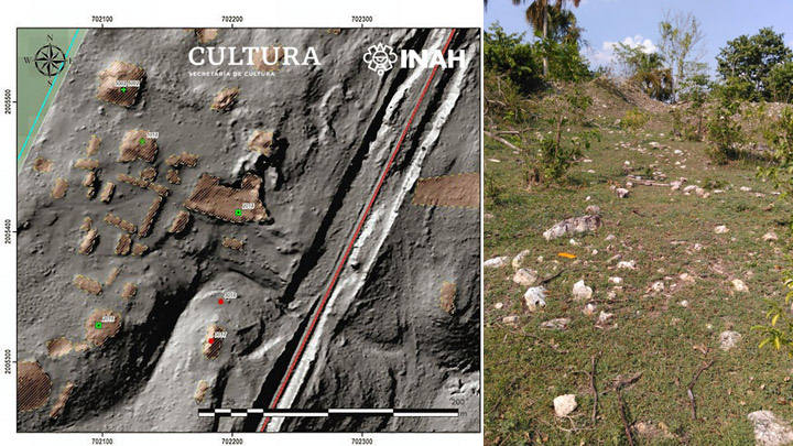
Mexico’s National Institute of Anthropology and History, conducting the archaeological survey required before construction of the Tren Maya railway project could proceed through the Yucatan Peninsula, deployed LIDAR technology across the 223-kilometer Section 1 corridor between Palenque and Escárcega and identified something that no prior archaeological survey of the region had documented: two major Maya urban complexes near the municipality of Candelaria in Campeche state whose scale, according to the INAH’s institutional communication, is comparable to Tikal.
Tikal, in northern Guatemala, is the largest documented Classic Maya city in the archaeological record. Its documented extent covers approximately 16 square kilometers of mapped urban area, with a central monumental core containing pyramids that reach 70 meters in height and a total documented population during its Classic period peak of approximately 60,000 to 90,000 people. Whether the Candelaria comparison is architectural in scale, civic in complexity, or demographic in implied population is not yet established because the surface prospecting phase documented in the INAH communication has not yet been followed by excavation.
What is established is that two major urban complexes existed near Candelaria whose existence was entirely unknown to the documented archaeological record before the Tren Maya survey’s LIDAR imagery revealed their outlines beneath the vegetation cover.
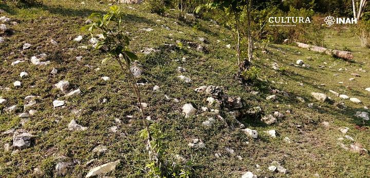
The first complex contains at least 91 structures documented in the field prospecting phase that followed the LIDAR imagery analysis. The specific building types documented include pyramidal bases, plazas, quadrangles, and terraces, whose specific combination is the standard signature of a Classic Maya civic-ceremonial center with surrounding residential zones. A large basement structure on which multiple mounds stand is described as the complex’s most prominent feature. Some of the documented buildings show partial damage from the construction of an earlier railway line through the region, whose specific route passed through the complex without documentation of what it was cutting through.
The second complex contains 37 elements of monumental and residential character whose specific documentation the INAH communication notes as requiring more detailed survey before the full extent of the complex can be assessed.
Neither complex has been excavated. No chronological data is yet available from either site. What has been documented is their existence and their scale.
The Survey Context and What It Is Revealing
The Tren Maya Project’s archaeological survey is the largest systematic LIDAR-and-field-prospecting survey of the Mexican Maya lowlands in the history of the region’s archaeology, and its documented results are transforming the conventional picture of Maya settlement density in Campeche state.
Section 2 of the project corridor, running 234.94 kilometers from Escárcega to Calkiní, has been completely surveyed and has documented 1,634 archaeological monuments of varying types including residential structures and civic-ceremonial complexes. Whether the 1,634-monument count represents the complete archaeological content of the surveyed corridor or reflects the density of features large enough to be identified through the specific LIDAR resolution and field survey methodology used, is the question that the survey’s methodology would address in a complete technical publication of its results.
The specific implication of 1,634 monuments across 235 kilometers of corridor is the density figure that most directly connects the Tren Maya survey to the broader LIDAR revolution in Maya archaeology documented in the Aguada Fénix piece. The PACUNAM LIDAR Initiative’s 2018 survey of approximately 2,100 square kilometers of northern Guatemala revealed approximately 60,000 previously unknown Maya structures and implied a Classic period population of 7-11 million people in the surveyed region. Whether the Tren Maya survey’s Campeche corridor density, if it could be extrapolated across the broader region, implies a similar revision of conventional population estimates for the Mexican Maya lowlands, is the question that the survey’s results motivate examining.
The 553 archaeological monuments documented in Section 1’s 131 surveyed kilometers, and the 1,634 monuments in Section 2’s 235 kilometers, represent densities of approximately 4.2 monuments per kilometer and 6.9 monuments per kilometer respectively. Whether this density variation reflects genuine archaeological differences between the two regions, differences in survey completeness at the time of the report, or variations in the definition of monument that was applied across the two sections, is the question that the raw numbers raise for the survey’s broader significance.
The Candelaria Complexes and the Tikal Comparison
The specific Tikal comparison in the INAH institutional communication is the element of the Candelaria discovery whose significance for the library’s framework requires most careful development.
Tikal’s documented archaeological profile includes a central acropolis complex with five major temple pyramids, an extensive causeways system connecting neighborhood centers to the civic core, documented evidence of hydraulic engineering including reservoirs and canal systems, and epigraphic evidence from carved monuments whose specific historical record spans approximately 500 years of dynastic history.
Whether the Candelaria complexes’ Tikal comparison refers to the scale of individual structures, the complexity of the urban layout, the implied population density, or the overall civic-ceremonial footprint of the two sites, is not specified in the INAH communication whose surface prospecting stage has not yet produced the excavation data that would allow a fully calibrated comparison.
What the LIDAR imagery and field prospecting have confirmed is the presence of pyramidal bases, plaza groups, quadrangles, and terracing whose specific configuration implies the same urban planning principles that govern documented Classic Maya cities elsewhere in the lowlands. The identification of a large basement structure on which multiple mounds stand in the first complex is the specific architectural form documented at multiple major Maya sites as the foundational platform for a civic-ceremonial precinct whose function included administrative, ritual, and residential activities for the site’s elite population.
Whether the Candelaria complexes were contemporaneous with Tikal’s Classic period peak, approximately 250-900 CE, are earlier Preclassic foundations whose surface expression was subsequently built over, or represent a regional tradition whose specific chronological relationship to the broader Maya lowlands tradition requires excavation data to establish, is the question that the current surface-prospecting documentation cannot answer.
The Railway Risk and the Institutional Tension
The Tren Maya Project’s specific institutional character, a contemporary infrastructure development whose construction corridor survey is producing major archaeological discoveries in the same process that is potentially threatening those discoveries, is the element of the Candelaria story whose development adds a dimension that the LIDAR archaeology pieces in the library do not otherwise cover.
The INAH communication’s specific statement about the survey’s purpose is explicit: the documentation was conducted to deliver specialized opinions to the National Fund for the Promotion of Tourism, Fonatur, that would guarantee the safeguarding of cultural heritage and the definition of the final project route. The survey is not primarily an archaeological research project. It is a regulatory compliance survey whose findings are intended to inform and potentially redirect a railway construction project whose economic and political investment is substantial.
Whether the Tren Maya Project’s final route will be modified to avoid the Candelaria complexes and the other significant archaeological sites documented in the survey, or whether the route decisions will be made on economic and political grounds that override the archaeological safeguarding recommendations, is the question that the institutional tension between infrastructure development and archaeological preservation raises.

The INAH communication’s specific note that some of the first complex’s structures were partially affected during the construction of an earlier railway line through the region is the documented historical precedent for what infrastructure construction without adequate archaeological protection can do to unexcavated sites: the earlier railway’s construction through the complex occurred before the LIDAR survey existed to reveal what was in the corridor.
Whether the Tren Maya Project’s survey, which was specifically designed to prevent the repetition of this pattern, will successfully redirect the railway route around the most significant documented complexes, or whether the survey will document what was destroyed in retrospect rather than what was preserved in advance, is the question that the institutional process is currently determining.
What LIDAR Is Still Finding
The Candelaria discovery is the latest in the documented series of major Maya urban complexes identified through LIDAR survey whose specific significance for the library’s framework the Aguada Fénix piece establishes: the conventional picture of Maya settlement, based on survey methodologies that could not penetrate forest canopy, systematically underestimated the density, scale, and sophistication of Maya urbanism across the lowlands.
The Aguada Fénix complex, documented in the library’s dedicated piece, established that the largest Maya monument in the archaeological record had been invisible to conventional survey for three thousand years until LIDAR found it. The PACUNAM survey established that the Guatemalan Maya lowlands contained approximately 60,000 structures whose existence was unknown before LIDAR documented them. The Tren Maya survey is establishing that the Mexican Maya lowlands contain similar densities of previously unknown archaeological monuments across a corridor that covers only a narrow strip of what LIDAR survey of the broader region would reveal.

Whether systematic LIDAR survey of the entire Maya lowlands of Mexico, Guatemala, Belize, and Honduras would produce a revision of Maya settlement and population history comparable to the revolution that the PACUNAM survey produced for the northern Guatemalan lowlands, is the question that the Tren Maya survey’s documented density figures motivate rather than speculatively propose.
The Candelaria complexes were under the vegetation when the earlier railway was built through them. They were under the vegetation when every archaeologist who surveyed the Campeche region on foot or from conventional aerial photography passed nearby. They were under the vegetation when satellite imagery of the region was analyzed without LIDAR penetration of the canopy.
The LIDAR looked down and found 91 structures in one place and 37 in another, both comparable to Tikal, both previously unrecorded.
If this density of unrecorded Tikal-scale complexes exists along a narrow railway survey corridor, the question of what exists across the broader Maya lowlands whose LIDAR survey has not yet been conducted is no longer a speculative question.
It is a logistical one.