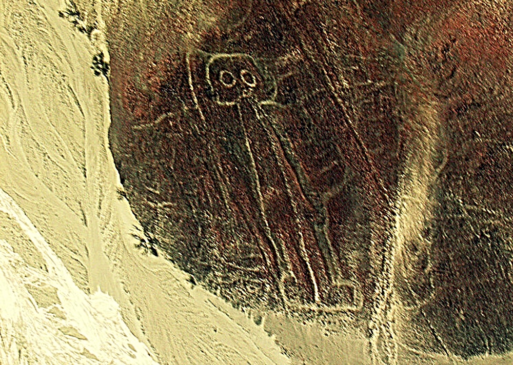
Mysterious geoglyphs, large motifs etched onto landscape, are found in isolated places throughout the entire world, and some are confirmed to be thousands of years old.
What is Geoglyph
Each of the eleven geoglyphs covered here has a distinct history, discovery story, and, often, still-debated dating, best explored individually rather than treated as one uniform mystery.
A geoglyph is, by definition, a large design or motif, generally longer than 4 metres, produced directly on the ground and typically formed by clastic rocks or similarly durable elements of the surrounding landscape, such as stones, stone fragments, live trees, gravel, or bare earth.
It is widely believed these enormous ground drawings have been created by ancient cultures in the distant past. Most of them, remarkably, can only be fully viewed and appreciated from high in the air. Who was the intended audience for these geoglyphs if they were created at a time before air travels possible?
Who built them and why remains, in most cases, an unresolved mystery, and the purposes attributed to them are almost as varied as their actual shapes and locations.
Here’s our list of 11 of the most mysterious geoglyphs, structures that can only be properly spied from high up in the air.
Modern Archaeological Dating Methods
The scientific methods archaeologists actually use to date geoglyphs like these are considerably more rigorous than guesswork and deserve explaining. Radiocarbon dating, used to help date the Russian moose geoglyph, measures the predictable decay rate of carbon-14 in organic material, a Nobel Prize-winning technique developed by chemist Willard Libby in the 1940s. For geoglyphs made of arranged stones rather than organic material, archaeologists often instead rely on optically stimulated luminescence dating, which measures when buried sediment grains were last exposed to sunlight, alongside stylistic and technique-based comparisons to securely dated tools and artifacts found in the same archaeological layer. ongoing pollen analysis at the Zyuratkul moose site, still in progress, aims to further refine the dating using preserved ancient pollen grains, an additional line of scientific evidence expected to help settle the geoglyph’s precise age with even greater confidence.
Why So Many Geoglyphs Can Only Be Seen From Above
The interesting question raised at the outset deserves direct address: why were so many of these structures built at a scale only fully appreciable from altitudes their creators couldn’t have reached. Archaeologists studying the Nazca Lines specifically have proposed several explanations worth knowing, including the theory that the figures were intended for viewing by deities in the sky rather than human observers, a culturally consistent explanation given documented evidence of ritual and ceremonial use at many Nazca sites. Researchers have also noted that walking along the lines themselves, an experience actually possible from ground level, may have constituted the intended ritual act itself, with the overall figure’s shape mattering more as a symbolic whole than as something meant to be visually appreciated at once. This ongoing archaeological question, why monumental art gets built at a scale exceeding its creators’ own viewing capability, applies across many geoglyph sites worldwide and remains an actively debated area of scholarly interpretation rather than a settled mystery.
1 – Nazca Lines, Peru

The Nazca Lines (sometimes spelled Nasca Lines) are hundreds of geoglyphs, abstract and figural art etched into part of the several hundred square kilometers of the Nazca Pampa landscape called the Pampa de San José in coastal northern Peru.
It is believed they were created sometime between 200 B.C. and 500 A.D.
They consist of hundreds of figures, many of which depict animals such as hummingbirds, sharks, monkeys, spiders, orcas, lizards and even an alleged “spaceman.”
2 – The Badlands Guardian, Canada

The Badlands’ Guardian is near Medicine Hat in the south-east of Alberta and not far from the border with the USA. The location of the geological wonder is very remote, in an area that has been traditionally the home of the Siska First Nation People, often known as the Blackfoot tribes.
The geological wonder, the Guardian of the Badlands was only uncovered in recent years and purely by chance. It is a geographical feature that, when seen from the air, resembles the face of an indigenous person in profile. The Indian head is looking westward and it is very large and even bigger than the heads on Mount Rushmore. It has the distinctive features of a First Nations male and it appears to be wearing traditional headwear, a feather headdress, which is synonymous with Aboriginal culture.
The geological feature was produced several hundred years ago or more, probably because a fierce storm unleashed flooding and winds that eroded the clayey soil and sedimentary rocks. The erosion left gullies and channels that have by complete chance formed the image of the Indian head if seen from a great height. No one believes that the feature was created by humans, but it is the result of natural processes.
The feature was discovered during the Google Earth project when they used satellite imagery and reproduced them in 3-D which led to the identification of the natural world. The Guardian is regarded as one of Google Earth’s most remarkable finds.
3 – Marree Man, Australia

The Marree Man is the second largest geoglyph in the world. It depicts an indigenous man hunting birds or wallabies with a throwing stick.
The Marree Man was first noticed on June 26 of 1998 by a pilot who was flying over the remote region. It has been determined that geoglyph was created in modern times. Nevertheless, its origin, meaning and purpose remain a mystery.
4 – Paracas Candelabra, Peru

This stunning geoglyph can be found on the northern face of the Paracas Peninsula at Pisco Bay in Peru, and is believed to date to around 200 B.C. Its purpose and meaning are unknown, though speculative theories abound.
Local legend suggests it represents the lightning rod or staff of the god Viracocha, who was worshipped throughout South America. But others have suggested it could have been constructed as a sign to sailors, or even as a symbolic representation of a hallucinogenic plant called Jimson weed.
5 – Works of the Old Men, Arabian Peninsula

Hundreds of thousands of geoglyphs are scattered across Saudi Arabia, Syria and Jordan depicting an array of “wheels,” among other motifs. Dubbed the “Works of the Old Men,” the features are believed by some to be several thousand years old, which would make them far older than the more famous Nazca Lines.
It still remains unknown: when were they built, and why?
6 – Atacama Geoglyphs, Chile

The Atacama Geoglyphs are located in the coastal desert of Chile. There were more than 5,000 geoglyphs built between 600-1500 CE, made by moving around the dark desert pavement. In addition to figural art including llamas, lizards, dolphins, monkeys, humans, eagles, and rheas, the Atacama glyphs include circles, concentric circles, circles with dots, rectangles, diamonds, arrows, and crosses.
Atacama Giant

The Atacama Giant (119 meters high) is the largest prehistoric anthropomorphic figure in the world. It is believed to represent a deity for the local inhabitants who created it between A.D. 1000 and 1400. But the figure has also been the subject of wild theories about its meaning that involve conjectures about alien visitations.
7 – Russian ‘Moose’ Geoglyph, Russia

The stone structure, located near Lake Zyuratkul north of the Kazakhstan border, features an elongated muzzle, four legs and two antlers.
The 900ft “animal”, which was discovered in 2011, is covered by a layer of soil and faces north on the Zyuratkul ridge.
This geoglyph was discovered in 2011 by local historian Alexander Shestakov, and initial estimates based on the stone-working style, called lithic chipping, suggested a date range of 6,000 to 3,000 BC. Subsequent radiocarbon dating conducted on 155 stone tools excavated from the site by archaeologist Stanislav Grigoriev of the Chelyabinsk History and Archaeology Institute narrowed this estimate to a more precise range of 4,000 to 3,000 BC. Physical evidence from the varying sizes of the recovered tools suggests both adults and children participated in construction. Even at this more conservative dating, the moose geoglyph remains considerably older than Peru’s Nazca Lines, the earliest of which were created around 500 BC, making it among the oldest known geoglyphs in the world.
The Ongoing Amazonian Geoglyph Research
The archaeological research into the Amazonian geoglyphs mentioned above has moved considerably beyond the initial deforestation-era discoveries and deserves expansion here. Archaeologists, including researchers publishing through institutions like the University of Exeter, have documented over 450 geoglyph sites across the Brazilian state of Acre alone, extensive earthworks including ditches, embankments, and enclosures often several hundred meters across. Published radiocarbon dating places most of these sites between roughly 200 BC and 1300 AD, considerably more recent than the Russian moose geoglyph but still ancient in their own right. Archaeologists studying these sites have found documented evidence complicating older assumptions that the Amazon rainforest was largely untouched wilderness before European contact, published research indicating sophisticated, organized pre-Columbian societies actively managed and shaped considerable portions of the Amazon basin. This ongoing archaeological program represents an active area of scientific inquiry rather than a settled mystery, with new sites continuing to be identified through satellite imagery and, increasingly, through airborne LiDAR surveys capable of detecting structures even beneath dense forest canopy.
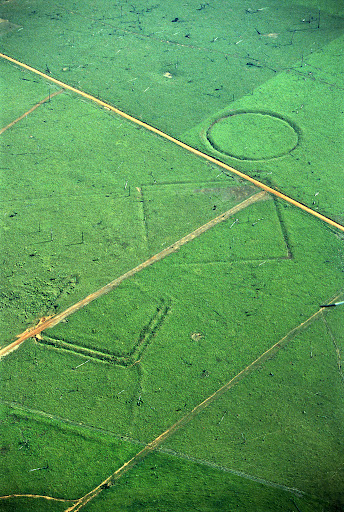
Since the 1970s, deforestation has revealed a complex network of mysterious ancient geoglyphs in the Amazon basin, possibly built by a lost Pre-Columbian civilization.
If this is true, it could completely rewrite the book on ancient cultures and population density of prehistoric South America.
9 – Blythe Intaglios, USA

These remarkable intaglios (anthropomorphic geoglyphs) are found near Blythe, Calif., in the Colorado Desert, along the Colorado River. Created simply by scraping away layers of darker rocks to reveal the lighter rocks beneath, the figures have remained preserved over the millennia thanks to the dryness of the region.
Believed to have been originally created by the Mojave and Quechan Indians around A.D. 1000, the figures weren’t discovered until 1932, when a pilot happened to look down and notice them.
10 – Uffington White Horse, UK

This highly stylized prehistoric hill figure, dubbed the Uffington White Horse, is in the county of Oxfordshire, England. Scholars suggest the feature, which is formed from deep trenches filled with crushed white chalk, was probably first created during the Bronze Age between 1200 B.C. and 800 B.C.
Though it is widely believed to depict a horse, there are some who claim it more closely resembles a big cat of some kind, which would be a mystery indeed, as there are no big cats that roam Great Britain.
11 – Big Horn Medicine Wheel of Wyoming, USA
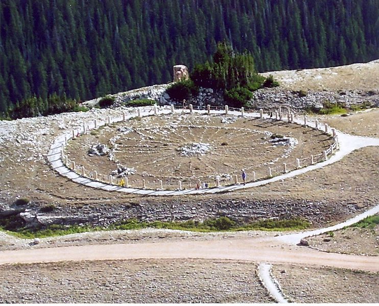
A mysterious pattern of stones sits at the summit of Medicine Mountain, nearly 10,000 feet above the Bighorn Range in Wyoming. Covered by heavy snows for most of the year, the stone configuration reveals itself and its purpose only in the summer months.
It is believed the geoglyph was built about 1300 AD .The stones are arranged in the shape of a wheel, 80 feet across and with 28 spokes emanating from a central cairn.
Known as medicine wheels, or sacred hoops, these special structures have been built by American Indians for centuries. With uses ranging from the ritual to the astronomical, the medicine wheel has been appropriated over time by New Age spiritualists, Wiccans, and Pagans.