


The map was drawn on gazelle skin.
Piri Reis, an admiral in the Ottoman Navy and a cartographer of established reputation, completed the map in 1513 CE. He drew it in Constantinople, working from a collection of source documents that he documented in his own annotations on the map’s margins: twenty source maps, some from his own time, others he described as dating to the era of Alexander the Great, and at least one he identified as originating from the time of the ancient Egyptian rulers. The map was drawn using plane geometry on a projection centered on the intersection of the equator and the zero meridian whose mathematical precision the cartographers who later analyzed it found remarkable.
The map was discovered in 1929 during a survey of the Topkapi Palace in Constantinople. It had been in the palace archive for more than four centuries.
When researchers examined what the map’s southern extension appeared to show, the discussion that followed has not been resolved in the subsequent nine decades.
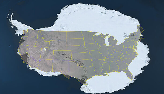
The map’s southern portion appears to show a continental landmass along a latitude corresponding to approximately 70 degrees south, with a coastline that features suggest corresponds to the Queen Maud Land region of Antarctica. The anomaly is that Antarctica was not discovered by European expeditions until 1820, three hundred and seven years after the Piri Reis map was completed, and was not comprehensively coastline-mapped until the twentieth century.
Whether the map shows Antarctica at all, shows an imagined southern continent of the type that European cartographers conventionally added to balance the northern landmasses, or shows a genuine geographical record of a coastline that was accessible to human observation before the ice sheet covered it, is the foundational interpretive question that has driven the Piri Reis debate since 1929.
The geological question that the third interpretation requires is specific: was any portion of Antarctica’s coastline ice-free recently enough that human observers could have mapped it and transmitted that information through the chains of cartographic tradition that eventually reached Piri Reis’s source documents?
What the Geology Says
Antarctica’s geological history is documented in ice cores, sediment records, and paleoclimatological studies whose conclusions are relevant to the Piri Reis question but whose numbers are more nuanced than either side of the debate typically acknowledges.
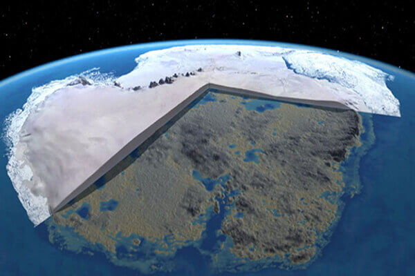
The Antarctic ice sheet began forming approximately 34 million years ago as the continent drifted to its current polar position and the Drake Passage opened, allowing the Antarctic Circumpolar Current to thermally isolate the continent. This long-term ice sheet formation is the geological baseline that makes the conventional scientific dismissal of the Piri Reis hypothesis reflexive: Antarctica has been ice-covered for tens of millions of years, far longer than modern humans have existed.
The nuance is in the Holocene record. The Antarctic ice cores and marine sediment records document that the Antarctic ice sheet has not been static during the Holocene. The last glacial maximum approximately 20,000 years ago had a substantially larger ice sheet than today. The subsequent deglaciation produced documented ice loss that continued through the Holocene. portions of the West Antarctic Ice Sheet have been documented as having been more dynamic than previously thought, with documented periods of reduced ice coverage during the Holocene thermal maximum approximately 9,000-6,000 years ago.
Whether any coastal region of Antarctica was genuinely accessible, without extensive sea ice and with a coastline approximately matching what the Piri Reis map shows, approximately 6,000-12,000 years ago, is the scientific question that the Holocene deglaciation record motivates examining rather than dismissing.
The dating of approximately 6,000 years ago for the end of the last ice-free phase in portions of the Antarctic coastal region, cited in the piece’s source, corresponds to the period when the Holocene thermal maximum’s warmth was subsiding. Whether this timing is accurate for the Queen Maud Land coastal region rather than for other portions of the Antarctic coast is a question that the regional paleoglaciology of the Queen Maud Land area would address.
Hapgood’s Analysis and the Air Force Cartographers
Charles Hapgood’s engagement with the Piri Reis map and the ancient cartography question was not simply the work of an amateur alternative researcher. His published methodology and the institutional involvement in his analysis are documented in ways that distinguish his work from the standard alternative archaeology treatment.
Hapgood’s 1966 book Maps of the Ancient Sea Kings: Evidence of Advanced Civilization in the Ice Age published the results of an extended analytical project that included consultation with the Engineering Division of the Aeronautical Chart and Information Center of the US Air Force. The Air Force cartographers who examined the Piri Reis map’s projection and accuracy in response to Hapgood’s research produced a documented assessment whose findings included the observation that the map shows no errors that any cartographer of 1513 should not have made, implying that its accuracy in certain respects exceeded what the known cartographic knowledge of Piri Reis’s period would have produced.
Whether this assessment constitutes institutional endorsement of the ancient civilization hypothesis or simply reflects the professional assessment of technical questions about the map’s projection mathematics without addressing the hypothesis itself, is a question that the context of the Air Force correspondence, documented in Hapgood’s book, partially addresses.
Hapgood’s conclusion was carefully stated: the evidence indicates that some ancient people explored Antarctica when its shores were free of ice, and that they had navigational instruments for determining longitude that were superior to anything in the modern world until the second half of the eighteenth century.
The longitude determination problem is the technical issue that makes Hapgood’s hypothesis most interesting. Accurate longitude determination requires precise timekeeping technology that was not available until the development of the marine chronometer in the eighteenth century. Whether any pre-modern cartographic tradition possessed an alternative method of accurate longitude determination is a question that the accuracy of the maps’ longitude coordinates would allow to investigate.
The Oronteus Finaeus Map and the Convergence Problem
The 1531 Oronteus Finaeus map, drawn by the French mathematician and cartographer Oronee Fine, shows a large southern continent whose general shape has been compared to Antarctica’s actual coastline by multiple researchers, including Hapgood, with more and less persuasive results depending on the comparison method used.
The map was made eighteen years after the Piri Reis map and two hundred and eighty-nine years before Antarctica’s conventional discovery. Whether Fine was drawing from source documents in the same tradition as Piri Reis, making an educated cartographic guess about a southern balancing continent, or coincidentally approximating Antarctica’s shape through the natural tendency of speculation to produce landmass shapes that superficially resemble real coastlines, is the interpretive question that the Oronteus Finaeus map raises.

The convergence problem is the most significant methodological issue in the ancient Antarctic cartography debate: if multiple independent maps from different periods and different cartographic traditions show features that correspond to Antarctic coastlines, the independent development of the same coincidental errors becomes progressively less likely as a complete explanation.
The Piri Reis map and the Oronteus Finaeus map are not identical in their Antarctic representations. They show different aspects of a coastline whose total known extent in both maps together has been argued to correspond to the actual Antarctic coastline more closely than chance would produce. Whether this correspondence is statistically significant or reflects the pattern-matching tendency that produces meaning in ambiguous shapes is the question that formal statistical analysis of the map-coastline correspondence would address.
Formal statistical analysis of this correspondence has not been published in the mainstream cartographic or paleogeographic literature. The debate has proceeded largely through qualitative comparison rather than through quantitative analysis whose results would be more definitive.
The Library of Alexandria and the Knowledge Chain
The transmission chain that Hapgood’s hypothesis requires, from ancient Antarctic cartographers through the Library of Alexandria to the Ottoman Imperial Library to Piri Reis’s 1513 map, involves the most important ancient repository of geographical knowledge in the documented record.
The Library of Alexandria’s documented holdings included geographical works from throughout the ancient Mediterranean and Near Eastern world, whose content in terms of cartographic documents is not fully known because the library’s destruction removed the original records. Whether the library held ancient maps of regions beyond the Mediterranean world is suggested by ancient textual references to geographical knowledge of remote regions but is not definitively established in the available ancient historical record.

The documented transmission path from Alexandria to Constantinople follows the documented history of Byzantine imperial collection of ancient manuscripts and maps during the periods when Byzantine scholars systematically preserved classical learning. The documented role of the Byzantine imperial libraries as repositories of ancient geographical knowledge is established in the Byzantine scholarly tradition, and the subsequent transmission to Ottoman hands during the conquest of Constantinople in 1453, when Piri Reis was born approximately five years later, provides the documented institutional pathway through which ancient source documents could have reached Piri Reis’s collection.
Whether this pathway actually transmitted ancient Antarctic cartographic knowledge is the question that the documents themselves would resolve if the original source maps that Piri Reis worked from were available for examination. They are not. What is available is the 1513 map that Piri Reis produced from them and his own annotations describing their character.
The Antarctic Pyramid Question
The piece’s opening reference to pyramid-shaped mountains in Antarctica visible as the ice sheet thins provides the visual hook that most contemporary treatments of the ancient Antarctic civilization question use. The mountains in question are the three triangular peaks near the Ellsworth Mountains documented in satellite imagery and popularized in alternative research discussions in approximately 2013.
The mainstream geological explanation for these formations is nuraghe, pyramidal horn mountains produced by glacial erosion from multiple sides simultaneously. The Matterhorn in the Swiss Alps is the standard comparative example of this formation type.
Whether the Antarctic pyramidal peaks are glacially eroded natural formations or reflect something whose character the conventional explanation does not account for is a question that ground-level geological survey of the peaks would address definitively. Whether such survey has been conducted and published in the accessible literature is not established in the available record.
What the pyramidal peaks add to the ancient Antarctic civilization question is visual impact rather than evidentiary content. The Piri Reis map’s documented existence and Hapgood’s documented analysis are the evidential core of the hypothesis, not the satellite imagery of triangular mountain peaks.
What the Evidence Establishes
The Piri Reis map is documented as a genuine 1513 cartographic document. Its apparent representation of an Antarctic coastline is documented as an interpretive controversy that has not been resolved in mainstream cartographic scholarship. Hapgood’s analysis, including the Air Force cartographers’ involvement, is documented. The geological evidence for Holocene Antarctic deglaciation is documented. The Library of Alexandria’s role as a repository of ancient geographical knowledge is documented.
Whether an ancient maritime civilization with accurate longitude determination capability mapped Antarctica’s coastline before the ice sheet covered it and transmitted that cartographic knowledge through the Library of Alexandria to eventually reach Piri Reis’s collection is a hypothesis that the documented evidence motivates examining without the available evidence establishing.
The Oronteus Finaeus map was drawn in 1531. The Piri Reis map was drawn in 1513. Antarctica was discovered in 1820. The geological evidence documents reduced Antarctic ice coverage during the Holocene. The Library of Alexandria documented ancient geographical knowledge from throughout the known and possibly unknown world.
Whatever the ancient sailors who compiled Piri Reis’s source documents were mapping, they were mapping something that looked enough like Antarctica’s ice-free coastline that one of the most accomplished cartographers of the sixteenth century drew it onto the southern edge of his most important map.
Whether that something was Antarctica, and whether anyone walked on its beaches before the ice came back, is the question that the gazelle-skin map has been asking since 1929.