




Ancient Hyperborea is Greek and Roman legend, and the 16th-century Arctic maps discussed below are documented historical artifacts. What is not supported by any credentialed cartographic history is the claim that these maps depict an actual landmass that physically existed and sank sometime in the 1500s. The explanation is more mundane, and considerably better established.
Hyperborea, meaning “beyond the north wind” in Greek, is ancient legend. Ancient writers including Herodotus, Pliny the Elder, and Pindar really did describe it as a utopian northern realm. That much is verified classical literature. What follows is an accurate account of the actual 16th-century maps this tradition draws on, and why historians of cartography explain them very differently than a sunken continent theory does.
What Mercator’s Map Actually Shows
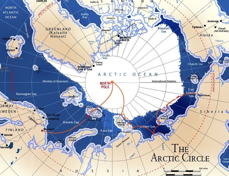
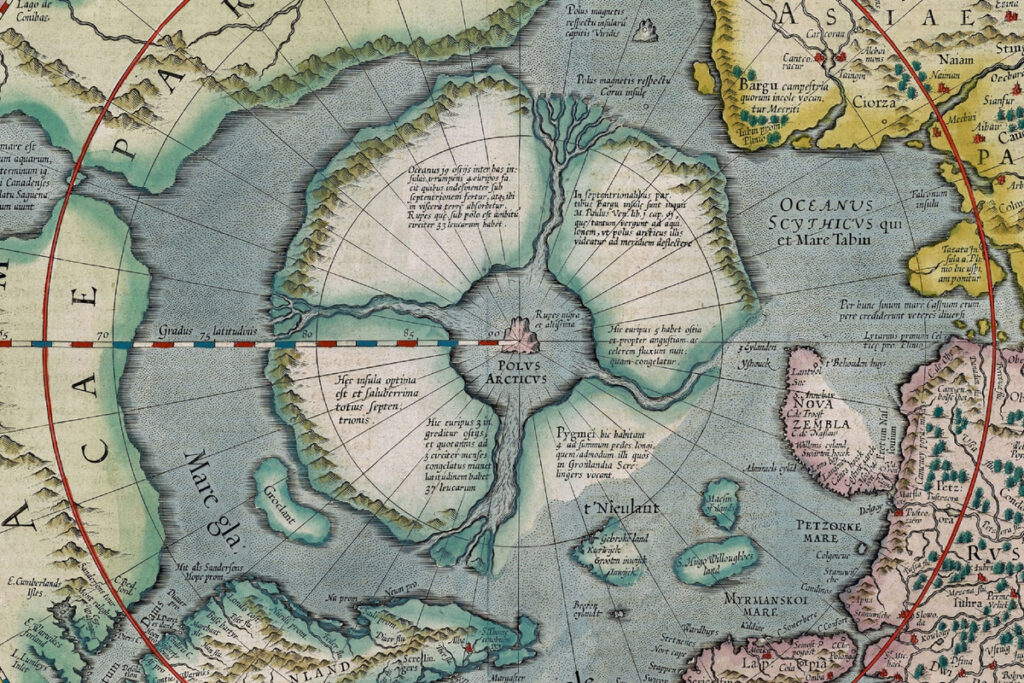
This deserves careful attention, since the sourcing behind Mercator’s famous Arctic depiction is thin, secondhand, and well established by historians. Gerard Mercator’s 1569 world map, and his more detailed 1595 polar map, do show four islands surrounding a magnetic black rock, the Rupes Nigra, at the North Pole. Mercator’s source, confirmed in his own surviving 1577 letter to English mathematician John Dee, was not eyewitness cartographic survey. It was a secondhand account: Mercator relayed a summary written by traveler Jacobus Cnoyen, who claimed to have encountered an unnamed Franciscan friar from Oxford who supposedly wrote a book, now lost, called Inventio Fortunata, describing a voyage to the far north.
That is the complete chain of sourcing behind one of history’s most famous depictions of an Arctic landmass: an anonymous author, a lost manuscript, relayed through a secondhand summary, transcribed in a private letter decades later. Historians of cartography note that the same lost source also described one of the four polar islands as inhabited by “Pygmei,” a race of people four feet tall, a detail widely believed by historians to be a garbled, secondhand account of actual Arctic peoples, most likely the Inuit or Sami, rather than literal evidence of a hidden race.
Historians of cartography have also traced the deeper roots of this depiction even further back, to purely theoretical Ptolemaic geography, the idea, inherited from ancient Greek cosmography, that magnetic phenomena required some kind of physical source at the pole. This was an ancient theoretical guess, not an empirically surveyed discovery, centuries before Mercator ever drew a line.

Why Cartographers Kept Copying It
Historians of cartography have identified exactly the mechanism responsible for this depiction appearing across multiple maps from Ruysch in 1507 through Oronce Fine in 1531 and the Zeno brothers in 1558: a well-documented pattern in the history of mapmaking, where an error introduced by one respected cartographer gains authority simply by being copied, and subsequent mapmakers, working in genuinely unexplored territory with no way to verify the claim themselves, repeat it rather than invent a fresh version. This phenomenon, sometimes called cartographic error propagation, explains why the same basic four-island Arctic layout, and comparable speculative Antarctic landmasses drawn before Antarctica’s actual 1820 discovery, recur across multiple independent 16th-century maps without requiring any of them to reflect an actual, physically surveyed landmass.
The Oronce Fine 1531 map’s ice-free Antarctica works exactly the same way. Historians of cartography explain this historical artifact through the same ancient Greek theoretical assumption, that a large southern landmass must exist to balance the known northern continents, a purely conceptual convention called the Terra Australis hypothesis, inherited from classical geography and drawn from theory rather than observation, not evidence of an actual warmer, mapped epoch.
The Maps Didn’t Vanish Because Anything Sank
This deserves correction too. Historians of cartography have documented precisely when and why these Arctic features disappeared from maps: by around 1636, all trace of Mercator’s four polar lands, the Rupes Nigra, and the Arctic maelstrom had vanished from cartography. The reason was not catastrophe. It was empirical geography gradually and simply prevailing over inherited legend, as polar exploration accumulated actual observations that increasingly conflicted with the old, uncorroborated secondhand account, and cartographers stopped including a feature no one could verify.
Greenland, the Zeno Map, and the Little Ice Age
Greenland’s Norse settlements, established from the 10th through 15th centuries, are well established history, and their decline is well understood through established climatology rather than any sunken continent theory. The 1558 Zeno map, published by Nicolò Zeno claiming to record 14th-century voyages by his ancestors, is itself extensively studied by historians of cartography, who generally regard it as based on garbled, distorted, or partly fabricated source material, a well established case of cartographic unreliability similar to the Mercator polar depiction, not independent confirmation of a still-thriving Greenland in the 1500s.
The Little Ice Age, a well documented period of global cooling lasting roughly from 1300 to 1850, is established climate history with a well-understood cause: primarily reduced solar activity, including the recorded Maunder Minimum, combined with increased volcanic activity injecting reflective particles into the atmosphere. Climatologists have reconstructed this period through multiple independent lines of evidence, including tree-ring records, ice cores, and historical accounts of frozen rivers and failed harvests across Europe. None of this extensively corroborated climate science requires or supports a sunken Arctic landmass as a triggering event.
Barents, Dezhnev, and Ordinary Arctic Exploration
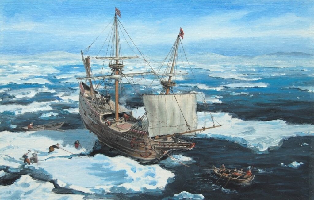
Dutch navigator Willem Barents did become trapped in Arctic ice near Novaya Zemlya in 1596, a well-documented historical event. This is straightforwardly explained by historians as the predictable result of an explorer relying on outdated, speculative charts, like Mercator’s, that had never been empirically verified in the first place, not evidence of sudden climatic catastrophe. Russian explorer Semyon Dezhnev’s 1648 voyage through the Bering Strait is likewise well established history, requiring no connection to any sunken landmass to explain.
Scaliger and the “Cover-Up”
This needs the most important correction of all. Joseph Justus Scaliger and his 1583 work De Emendatione Temporum are regarded by historians as a foundational advance in comparative chronology, careful scholarship cross-referencing calendar systems across multiple ancient civilizations to build a coherent shared timeline, still respected as pioneering work in the field today. The claim that Scaliger, working under Vatican influence, deliberately compressed history to erase evidence of a sunken Arctic continent is not supported by any credentialed historical scholarship. This is the same underlying pseudo-historical framework, sometimes called New Chronology, that has been extensively and specifically rejected by every relevant academic discipline that has examined it, historians have found no evidence anywhere in the historical or archaeological record supporting a deliberate, coordinated chronological cover-up of this kind.
Modern Arctic Geology, Explained Accurately
Geology and unfounded speculation get conflated often enough in Arctic discussions that this deserves its own careful, direct treatment. The geological research referenced in these theories is worth addressing directly, since it’s science being applied to an unsupported conclusion. Seabed mapping and plate tectonics research have identified underwater geological features in the Arctic, including submerged ridges like the Lomonosov Ridge, that some geologists have studied in connection with the region’s deep geological history. This research is established earth science. What geologists studying these features do not claim is that any of them represent a habitable landmass that existed as recently as the 16th century. Dating of Arctic seabed features relies on established geological methods, including sediment core analysis and radiometric dating, and these methods consistently place any relevant tectonic activity on timescales of millions of years, not centuries. The scientific concept of “Arctida,” when it appears in geological literature at all, refers to a hypothetical ancient landmass relevant to deep geological history, not a sunken medieval civilization.
Urbano Monte’s 1587 Map
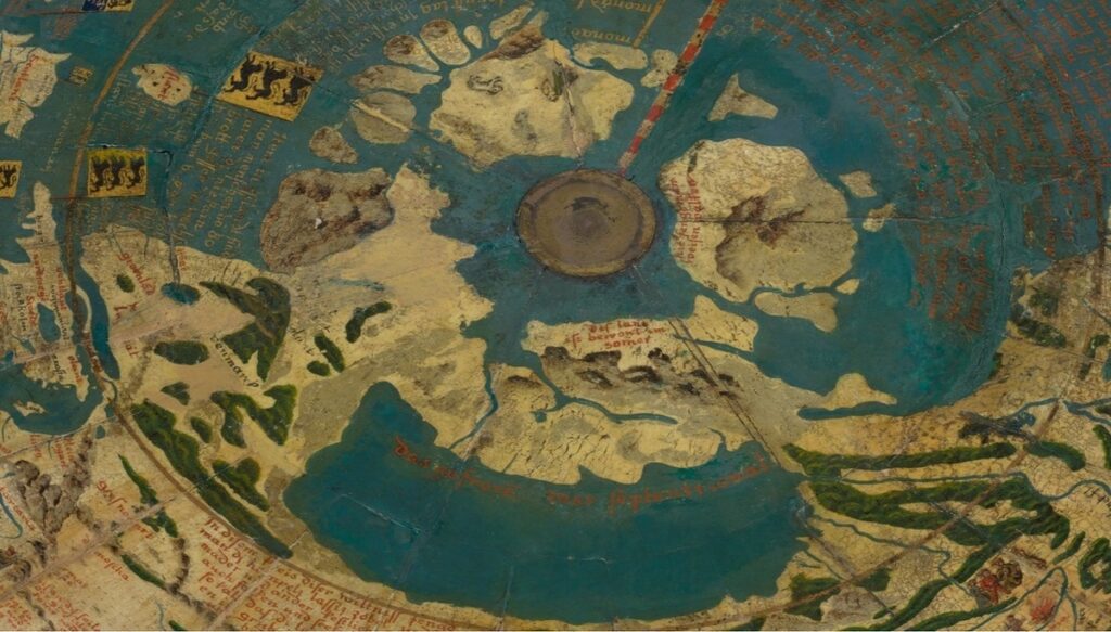
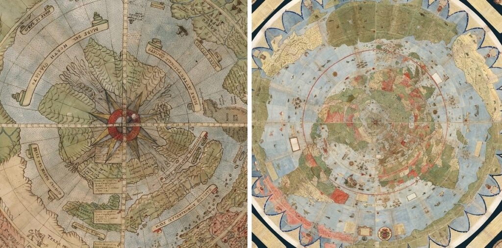
This remarkable historical artifact deserves its own additional detail, and accurate context of its own. Italian cartographer Urbano Monte’s 1587 manuscript map, assembled from 60 sheets and spanning over nine feet when fully joined, is an extraordinary achievement of Renaissance cartography, intended to be viewed from directly above the North Pole, an innovative perspective for its era. Historians who have studied this map extensively, including through a detailed digital reconstruction project completed by the David Rumsey Map Center at Stanford University, confirm it draws on the same broader tradition of speculative polar geography as Mercator’s work, incorporating elements of the same Inventio Fortunata-derived legend alongside contemporary exploration reports. Monte’s map is genuinely valuable as a historical artifact documenting how 16th-century Europeans understood and imagined the unexplored world, exactly the kind of rich cartographic history that doesn’t require an actual sunken continent to be worth studying closely.
What These Maps Actually Teach
The documented history of these maps is arguably more interesting than an invented sunken continent, since it shows exactly how European geographic knowledge of the Arctic actually developed: through a centuries-long process of inherited theory, secondhand legend, and gradually accumulating direct observation slowly correcting the record. Mercator, Ruysch, Oronce Fine, and the Zeno brothers were not liars, and they were not documenting a physical landmass. They were working cartographers filling in the genuinely unexplored edges of the known world using the best available sources of their era, sources that happened to include garbled legend alongside geography, exactly the kind of honest, traceable historical process historians have carefully reconstructed, source by source, letter by letter, without needing any hidden continent or chronological conspiracy to explain it. That patient historical reconstruction, tracing a single anonymous friar’s lost manuscript through Cnoyen’s summary to Mercator’s own hand, is a genuinely compelling story on its own terms.
Mercator’s Arctic maps are the actual physical evidence here, not proof of a vanished continent.