


The Japanese satellite Himawari-8 has managed to capture the columns of smoke that cover the sky from Australia to New Zealand. The southern country is plagued by forest fires so severe that even satellites can detect flames and smoke from space.
The Himawari 8, from the Japan Meteorological Agency, was launched in October 2014. It now orbits the same point about 36,000 km above our planet. The Japanese satellite provides a panoramic view of the Earth and takes photos every 10 minutes.
The image taken by the Himawari 8 satellite two hours ago shows how the smoke column of Australia’s fires has moved more than 3000 kilometers after yesterday covering practically the entire southern island of New Zealand. pic.twitter.com/ml3weQZp1A
– A geologist in trouble (@geologoenapuros) January 2, 2020
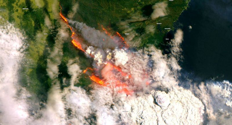
As many of us in the #EU are getting ready to celebrate #NYE2020, our thoughts are with all those affected by disasters, with refugees, with firefighters, emergency managers, paramedics etc. that are on duty in ?? & all over#Sentinel2??? image of the Bateman Bay #NSW area 31/12 pic.twitter.com/L9Do8wKRPc
— Copernicus EMS (@CopernicusEMS) 31 December 2019
Fires on the Australian continent began in September due to natural causes, but most likely they have reached the current magnitude due to climate change. So far, more than 14 million acres have burned, about 500 million animals have died and hundreds of thousands of people have been displaced. The death toll from the catastrophe is at least 19 people.